(From the editor, Feel free to use these comments for a template and send your own comments to
rowed@dot.state.al.us L. Dee Rowe, ALDOT 5th division before Dec. 19, 2010. Be sure and copy Lynne Urquhart Federal Highway Administration
Lynne.Urquhart@fhwa.dot.gov Also, Mark Bartlett
Mark.Bartlett@dot.gov )
To: L. Dee Rowe, Division Engineer
Alabama Department of Transportation
P.O. Box 70070
Tuscaloosa, Al 35407-0070
12/08/10
Comments of:
John L. Wathen, Hurricane CREEKKEEPER, and
Friends of Hurricane Creek
We were very frustrated with the October 26, 2010 "Design Hearing" discussing the Eastern Bypass. By placing the maps some 30 feet apart, the set-up made it impossible for the community to be together to hear and discuss the issues and problems concerning the selected corridor. The DOT representatives at each map location seemed evasive at times and did not fully answer all questions, oftentimes deferring the questions to other individuals who were not present. This led to people from ALDOT walking around asking questions of each other wasting valuable time. It never seemed that the purpose of the ALDOT "hearing" was to hear any of our comments.
A hearing is where people hear the project described, ask questions and get answers. A hearing is where people can give comment and publicly exchange information with the community. ALDOT employees often turned their backs on the community to talk to individuals about touchy subjects while crowds were left watching their backs and not HEARING a word of their neighbors concerns!
The stenographer recording comment was in the foyer with no sign or information visible showing where it was. Many voiced concerns about not being able to comment. ALDOT provided a piece of paper in the back of the handout with 6 lines on it double-spaced. No arrangements for on-line comments were made.
We have been disappointed many times in the past with ALDOT's seeming lack of interest in the community's need to protect our watershed. We remember the Hwy 216 bridge replacement. In the words of Paul Bowlin DOT Director, “We know that the 216 project was a disaster. We screwed up.”


In regards to the Eastern Bypass, first, a reevaluation of the Environmental Impact Study must be completed in the form of a supplemental EIS. A reevaluation of the entire project must be completed if major steps have not occurred within three years after the approval of the final EIS. 23 CFR 771.129. In this case, the final EIS was signed in January of 1999 and major steps such as gaining authority to buy significant right-of-way, or approving final plans have not taken place. A comprehensive reevaluation of the entire EIS must be completed, especially considering that the original EIS does not include indirect or cumulative impacts.
Further, there is overwhelming evidence that the Environmental Impact Study (EIS) is seriously flawed. Indeed, a commentary in the Tuscaloosa News by the Chairman of the Department of Geological Sciences at the University of Alabama pointed out numerous flaws in the original EIS. The decision to place such a large-scale project in such a sensitive area cannot be made without a complete and accurate survey. It is not sufficient to merely respond that the EIS "already has been approved." Alabama deserves better than to be singled out by the National Sierra Club as having one of the worst transportation projects in the country.
Time after time, we have pointed out that the current EIS is flawed and incomplete at best. There are plants located in the path of this road which have been documented as two of the most rare in the state. They are not listed in the EIS. There is the possibility of significant archaeological sites of interest in the area. In contrast with previous studies, a recent archaeology study done in the 70 or so acres in the “M” Bend Park showed significant cultural inhabitants.
In the 1998 EIS, ALDOT surveys missed 27 abandoned underground coal mine entrances in less than 1/2 mile of the corridor. They were obviously visible when ADIR abandoned mine expert Larry Barwick visited the site. There are many more yet disclosed in the “M” Bend Park area. ALDOT surveys were proven flawed on many levels. The document is well over 20 years old.
We need to know what exactly is going to be destroyed. A wildflower recovery should be implemented to insure propagation of these displaced species. A complete and independent survey is called for and it must cover all impacted species.
1. Surveys associated with the original EIS were severely flawed and mislead the public into believing the simplicity of building in this location and in this manner.
i. A recent archaeological survey by University of Alabama archaeologists showed many sites of significance which were denied by ALDOT in the first EIS.
ii. Biological surveys were proven false with the identification of rare and endangered species of fauna.
iii. Geological surveys were proven false with the identification of at least 27 abandoned coal mine entrances directly in the corridor that were denied by ALDOT in the first EIS. New entrances have been found within the PARA land since.
iv. These deficiencies on the original surveys suggest that the entire document is flawed and needs to be redone regardless of age.
There have been changes in the laws requiring a “Cumulative Growth Study” (“CGS”) and an “Environmental Impact Study” based on the CGS. This must be done.
Our concerns for this project do not start and stop with the “M” Bend. The entire corridor from just South of Crescent Ridge Road to the I-59 connection is in the TMDL protected segment of Hurricane Creek. Multiple wetlands will be disturbed in the Cottondale Creek watershed where flooding is already a problem. ALDOT should prove that they can maintain a 0 net gain increase in both storm-water flow and turbidity. Road shoulders should be of pervious surface to allow more absorption into the ground.
We believe that the mindset of ALDOT is that the Bypass route is already set and not subject to further modification. The current plan only serves political goals, not the best interests of the citizens of Tuscaloosa. We therefore strongly urge you to consider the following recommendations for the proposed Bypass. If you decline to incorporate these recommendations, we request that you provide us the reasoning behind that decision.
Recommendations for the proposed by-pass:
The most recent ground-up technology must be employed to construct the piers and spans that cross the creek. The current push and bury technique will not work in this sensitive area. Mr. David Kemp of the Tuscaloosa ALDOT office suggested it and we agree that it is the best approach to this area. No disturbance of the existing banks should be allowed. All piers should be placed well above the banks to facilitate game crossing.
The actual construction of the bridges in either location should reflect the beauty of the region. Instead of a monolithic slab construction, we would like to see a steel web and brace style four-lane mono-bridge, such as you see in the Appalachian region of West Virginia. A typical construction of two abutments, two pillars, and three spans with radius arches would allow for greater distance between disturbed areas along the creek. This would allow the banks of the creek to remain intact and act as a buffer zone.
The entire length of the corridor should be fenced to prevent game from wandering into traffic and also to control access to the creek by off road vehicles. All bridges should be fenced with in-curving tops to reduce blowing litter from entering waterways. Litter collection devices in the drain system need to be installed and a budget set aside for maintenance in the future.
An undisturbed game corridor should be left intact along the creek to encourage wildlife to cross under bridges and away from traffic danger zones. This will prevent needless deaths to the wildlife and reduce the number of animal related accidents.
Radius span construction will allow the natural flora and fauna to remain as the backdrop for a work of art instead of the tons and tons of rip-pap that will be needed to stabilize the banks if denuded. Also it would act as a game corridor to allow deer and other animals to travel the banks, as is their nature. The only wildlife that can flourish in the huge riprap piles is rodents and reptiles. Deer and other four-legged wildlife cannot cross the rocks without injury. In fact the deer will not even attempt to cross under the bridge but instead it will try to cross over the bridge where they become a traffic hazard.
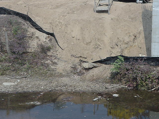
Erosion will be a very serious concern with this project. Hurricane Creek was listed on the EPA 303(d) list of impaired streams for the very pollutants that will be discharged during construction of these five bridges and connecting roads. There is now a Total Maximum Daily Load assessment (TMDL) that requires a 32% reduction in turbidity and 87% reduction for Iron. Both will be problematic in this area due to topography and abandoned coalmines found throughout the corridor.
ALDOT should maintain less than 20 acres of disturbed area at any one time. This means that disturbed areas will have to achieve a stable condition of reclamation before further disturbance can begin. We are deeply concerned about this requirement since ALDOT demonstrated on Buttermilk Road that it cannot control sedimentation in 25-acre increments.
No slope grade should exceed 3:1 throughout the project. The slopes on Buttermilk road failed early in the project and remained sources of erosion for the life of the project despite promises of repairs from ALDOT project supervisors. Slope grades above 3:1 cause problems during construction due to erosion. After construction they create problems for grass cutting and maintenance. Machines tear larges patches of grass out causing erosion and accidents due to tipping over.
The chosen corridor is inadequate to install retention ponds needed to contain the expected runoff from the site. Because of the adjacent streams and the steep nature of the terrain a comprehensive containment program must be included. This containment program must be implemented PRIOR TO ANY EXCAVATION to adhere to the reduction required in the TMDL approved for Hurricane Creek. The segments selected by ALDOT for the Eastern By-pass all lie within the Hurricane Creek watershed considered by EPA as a “priority stream”.

According to Geological Survey of Alabama (GSA) the fish count below Cottondale Creek is in decline. Above Cottondale Creek the count is improving. This is due to the impacts of irresponsible developers, poor planning, and, in part, ALDOT construction on Buttermilk Road and I-59. Use of polyacrylamides (PAM) should be held to a minimum and, if used, should be limited to only those PAMs approved for aquatic life. The TMDL requires a 32% reduction in turbidity, with which ALDOT will not be able to comply. Alternate routes would alleviate this concern altogether for this segment.
FoHC would entertain an action by ALDOT whereby it (ALDOT) would purchase other lands to offset the loss of this pristine section of Hurricane Creek. ALDOT will have to buy stream bank mitigation acreage during the Corps of Engineers permitting process. Those acres should be purchased in another part of the Hurricane Creek watershed and set aside in perpetuity as natural areas, wildlife preserves, and or public use areas.
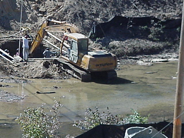
The abandoned mines in the path are especially problematic to this project because of the extremely acidic nature of the coal contained within. With no room for retention ponds there is no way to treat the runoff before it reaches Hurricane Creek.
 |
| Larry Barwick ADIR inspects abandoned coal mine |
This is an extremely fragile ecosystem on the EPA 303 list of impaired streams with an approved TMDL for Iron associated with coal mining. Therefore we respectfully ask that A.D.I.R. supervise the extraction of the coal and approve the method of removal of acid from runoff water.
NO mine waste should ever be used for stabilization. Currently materials coming from the Bunn operation at the Tuscaloosa Resources coal strip mine contain silicates and Iron that is released when exposed to weather. Only limestone should be used and that in very limited quantities during construction and removed after completion.
Along with the coal mines there is the problem of blasting the rock formations.
With the close proximity of residences in the area and the underlying mines throughout the area, there is a significant chance of damage to homes along the ridge.
Residents in the area have been advised to do a pre-blast survey of their homes to be used to prove damage during construction. ALDOT needs to assure the community of their intent to compensate them for damages. Use of hydraulic track hammers to break up the rock would be preferred.
During every season of the year people use this section of Hurricane Creek extensively. In high water canoes and kayaks will be in great danger under the bridges during construction. Safety netting should be extended at least 15 feet out and under the construction over every stream crossing to ensure no construction debris falls on someone.
At the recent so-called hearing, David Kemp, ALDOT, repeatedly stated that the road would be elevated to help protect the “M” Bend Park area. The drawings clearly showed benched terraces through the hills there. In the past, however, we were told the road would be excavated 60 feet into the mountain to address noise in Summerfield. Which is it?
We prefer an elevated roadway with energy diverting downspout storm water control measures.
The current map shows a third bridge on the Green Acres side that serves as an off ramp for Hwy. 216. A cloverleaf type off ramp after crossing the creek will eliminate the need for that third and costly bridge and cause less impact to Hurricane Creek and result in savings for taxpayers.
In conclusion, an alternate route will result in fewer bridges and secondary roads than shown on the current map. Altogether the change of route will save the taxpayers 50 million dollars due to the lack of need for 5 bridges over Hurricane Creek alone. This would be a huge savings to the taxpayers and would involve less residential displacement.
Since there is no “access road” included in the corridor plans through the “M” Bend Park, the bridges will have to be built first just to get equipment into the construction area. This is going to be an added expense of which ALDOT has not informed the public.
The chosen route will cause extensive residential displacement in this community. Virtually the entire community of Green Acres will be wiped out with the exception of a few houses left on a dead-end road with several secondary roads having to be built in order to allow access to homes left virtually under the bridges.
An alternate route will be less problematic and less costly to implement due to less residential displacement on both sides of the project.
Current landowners should be paid the maximum allowable under the law for having to be displaced. Landowners should be compensated for both the cost of replacing their homes and the cost of relocating, and not what ALDOT estimators consider to be “fair market value”. Holt and Cottondale lie in economically distressed areas where the threat of this project has degraded the property values for years. Moving out of the way of the corridor will be far more costly than the “value” of the devalued home. ALDOT must pay ALL incurred costs for residential displacement.
ALDOT must allow a timely relocation of residences in the corridor. Finding homes for these people will be a time consuming process and ALDOT must allow that time. The economy could not be worse for relocation at this time.
a. An alternate route will decrease the number of residentially displaced families and reduce the cost to the taxpayers and allow established families to remain on their land.
An alternate route will be more cost effective, less damaging to the fragile ecosystem of Hurricane Creek, cause less residential displacement, cause less damage due to blasting, and cause less concern over environmental issues, and will result as well in huge savings to the taxpayers of Alabama.
It is the final opinion of the Friends of Hurricane Creek that this project is far too problematic and costly to be seen as feasible.
Respectfully submitted,
Laurie P. Johns, President, Friends of Hurricane Creek
John L. Wathen, Hurricane Creekkeeper